

The monitoring of the coast with the drone, pros and cons
The experience of LIFE REDUNE, which has allowed not only to perform aerial photogrammetry in different areas of the Veneto coast, but also to confront in the context of networking and replication actions, with other projects that operate on different coastlines (eg. Life Primed, Life Calliope, Interreg CASCADE) has led to some conclusions on the advantages and limits of the use of the drone for beach monitoring, which we summarize below.
Advantages in the use of drones in the coastal area
the use of personnel is reduced and in the maximum flight time (45 minutes) it is possible to detect up to 8 km 2 of surface. The main cost is due to the equipment but is justified by the ease of relief.
Limits to the use of drones in the coastal area
The SAPR method has limitations, mainly linked to the constraints dictated by the characteristics of the intervention areas.
- Reconstruction of morphologies à the orthophotos at 5cm of pixels allow to recognize objects with dimensions of the order of 10cm but in terms of shape it is not possible to recognize objects that detach from the ground if they have dimensions less than 50-100cm, below this size will always be rebuilt at ground level.
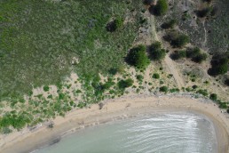
- Acquisition of data in the presence of dense vegetation à under the dense vegetation it is not possible to acquire the heights of the land.
- Authorization restrictions à to fly in close proximity to people (up to 50m), authorizations are required such as possession of the A2 license, however it is forbidden to fly over gatherings. Other restrictions may exist in the vicinity of airports or heliports.
- Weather conditions unlike a traditional survey it is not possible to carry out an aerial photogrammetric survey in any weather condition, in particular with strong wind.
Adapted from:
F. Carollo, A. Zarantonello, F. Piccolo, E. Fantinato, G. Buffa (2022). Guidelines for the use of drones in monitoring beaches. LIFE REDUNE
liferedune.it/linee-guida-e-manuali/