

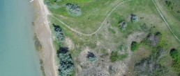
Laguna di Caorle - Foce del Tagliamento
Location
* The Municipalities of San Michele al Tagliamento, Caorle and Concordia Saggitaria
Area
4,385.000
Description
The site is located at the eastern boundary of the Veneto Region, on the border with Friuli Venezia-Giulia, in the area between the Tagliamento River, to the north-east and the Nicesolo Channel, to the south-west. The site is one of the most interesting environmental realities of the Veneto coastal system, with high ecological articulation that includes a rich mosaic of environments. The area’s remarkable singularity is expressed mainly in the system of stabilised dunes.
Area importance for biodiversity and conservation
The site has a very high ecological articulation that translates into a heterogeneous landscape and specific diversity, among the highest along the north-Adriatic coastal arch. Due to this, it has been identified as an “Important Plant Area” (IPA) called “Laguna di Caorle and Foce del Tagliamento” (cod. VEN5). The site is home to about 60% of the regional surface of 2130 * habitat and about 20% of the entire national surface, a factor that makes the site the most important conservation area for the habitat and the species that form it . The site also hosts a population of Stipa veneta* in its section of fossil dunes. Moreover, on the site there is about 75% of the entire, currently mapped, regional surface of 2250* habitat and 3 % of the surface expressed along the north-Adriatic arch.
Actions forseen by the project
- Redevelopment and extension of the shifting dunes system concentrated in the sub areas of Vallevecchia and Punta Tagliamento-Capalonga
- The redevelopment and extension of the edafo-xerophilous series habitat in the sub areas of Punta Tagliamento (2270*), Punta Tagliamento-Capalonga (2250*) and Vallevecchia, where work will involve all three habitats
- Strenthening the Stipa veneta* population
- Manual eradication of Oenothera stucchii
- Installation of 1800 m of fences and 750 m of walkways
- The positioning of descriptive panels about the environment
- Organisation of guided tours and education and training events
- Creation of a memorandum of understanding with the local stakeholders, for the long-term management of sites
Bosco Nordio
Location
Comune di Chioggia
Area
157.000
Description
The site includes a series of consolidated dunes that represent the most ancient dune system of the littoral between Chioggia and the Po and, as such, presents interesting naturalistic peculiarities and exceptional testimonial importance. In fact, it is one of the residual examples of climatic littoral forest, together with the Bosco di Valgrande di Bibione, the relict woods of the Cavallino Biophenological Station, and, outside the region, the Boscone della Mesola.
Area importance for biodiversity and conservation
The choice of this site, which differs from the other project sites due to some specific features, is linked tothe presence of the habitat 2250*, which in the Veneto Region shows appreciable cartographic areas only in this site (about 23% of the regional surface) and in the sites of the north-eastern coastal sector, included in the present project (Cavallino Peninsula and Caorle Lagoon - Mouth of the Tagliamento River). The inclusion of the Bosco Nordio site therefore allows recovery and improvement actions to be carried out on all the 2250* areas currently surveyed in the Region, which cover little more than 1 ha in total. Similarly, although the surface areas expressed in this site by the 2130* habitat are not very large, their requalification would make Bosco Nordio a source site for otherNatura 2000 sites located nearby and strongly isolated from the coastal sector by a predominantly rural landscape context.
Actions forseen by the project
- Redevelopment and extension of two priority habitats of the edaphorophilous series (2130* and 2250*) with a total area of approximately 24,000 m2
- Installation of fences (approx. 150 ml) to limit anthropogenic disturbance in the redeveloped areas
- Positioning of descriptive panels of the environment
.
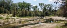
Laguna del Mort e pinete di Eraclea
Location
Municipalities of Caorle, Eraclea and Jesolo
Area
214.070
Description
A coastal system consisting of a limited size lagoon bordered by a sandbar, reinforced by vertical “groynes” along the coastline and flanked, along the entire length of the coastline, by a large pine forest. Connection to the sea is guaranteed by an artificial opening so the natural dynamics are partially altered. The lagoon area, still relatively untouched, is characterised by shallow, warm and calm waters with sandy bottoms partially covered by communities of marine phanerogams (Zosteretea marinae) and rich in phytoplankton and fauna species.
Area importance for biodiversity and conservation
The site is connected to the presence of priority dunal habitats of particular ecological-naturalistic value. It is one of the 31 Italian sites in which habitat 2130* is present, which on this site reaches a surface equal to 10% of the total surface area occupied by the habitats on a regional scale and 3 % of the surface relative to the north-Adriatic coastal arch. The site also represents one of the 8 sites in the upper Adriatic arch where the habitat 2250* is present, with excellent development potential. The three systems that make up the plant landscape of the Venetian dunes are well represented: the shifting dunes, the stabilised dunes (edafo-xerophilous series) and the humid interdunal lowlands, with both halophilic aspects (morphological mosaic of halophilous communities) and freshwater (edafo-hygrophilous series). The site also hosts species of significant conservation interest such as Stipa veneta *, a priority species of All. II, present in the European Red List of Vascular Plants (EN) and in the IUCN Red List of Threatened Species (EN). The inclusion of this site allows conservation actions on most of the species known area in Veneto and on a large part of the total species area.
Actions forseen by the project
- Redevelopment and enlargement (approximately 3,000 sq. m.) of the shifting dune system
- Redevelopment and extension of the edafo-xerophilous series habitats (action c4) for a total surface of about 220,000 sq. m
- Strengthening the Stipa veneta* population
- Manual eradication of Oenothera stucchii from a surface of approximately 67,000 sq. m.
- Installation of about 6,000 ml of fences and 150 ml of walkways to navigate tourist flows and protect work areas
- The positioning of descriptive panels about the environment
- Organisation of guided tours and education and training events
- Creation of a memorandum of understanding with the local stakeholders the long-term management of sites
Penisola del Cavallino - Biotopi litoranei
Location
Cavallino Treporti
Area
315.000
Description
The site, located in the Continental biogeographical region, occupies a portion of the Veneto coast called “Cavallino”, and hosts complex dunes of ancient and recent formation that extend from the current mouth of the River Sile to Punta Sabbioni. The site is divided into three areas located along the coast (Ca’ Ballarin, Ca’ Savio and Punta Sabbioni) and a fourth area towards the hinterland, corresponding to a fragment of a fossil dune known as the “Biophenological Station” in Cavallino (Vallesina locality).
Area importance for biodiversity and conservation
The importance of the site within the project is mainly linked to the presence of a edafo-xerophilus series that is well represented in quantitative terms. The habitat 2130* has a surface amounting to approximately 12% of the regional surface. The site represents one of the 3 regional sites in which the habitat 2250 * is present, with an area equal to 4% of the total. Its importance goes beyond a local level, representing 1 of the 8 2250* sites within the northern-Adriatic coastline and one of the 25 sites at a national level. Due to its climatic peculiarities, the Cavallino Peninsula has been identified as an “Important Plant Area” (IPA) called “Laguna di Venezia e Penisola di Cavallino” (cod. VEN4).
Actions forseen by the project
- Redevelopment and/or enlargement work of 3 priority habitats: 2130*, 2250* and 2270* for a total surface of about 215,000 sq. m.
- Manual eradication of Oenothera stucchii from approximately 12,000 sq. m.
- Installation of 900 ml of fences and 70 ml of walkways to navigate tourist flows and protect work areas
- Positioning of 8 external panels
- 3 internal information panels
- Organisation of guided tours and education and training events
- Creation of a memorandum of understanding with the local stakeholders, for the long-term management of sites