

Reducing anthropogenic impact on dune habitats
The aim of the LIFE REDUNE project is to guarantee the ecological functionality of the entire dune mosaic in four Natura 2000 sites through an ecosystem approach that considers all the components involved: human activities, habitats, species and physical processes.
The five intervention areas of the project are distributed along the stretch of Venetian coast between the municipalities of Chioggia and San Michele al Tagliamento: Bosco Nordio, Cavallino Treporti - Punta Sabbioni, Laguna del Mort and Pineta di Eraclea, Eraclea Mare, Vallevecchia, Punta Capalonga and Punta Tagliamento.
LIFE REDUNE interventions for the reduction of anthropic impact on habitats aim at facilitating the recovery of the integrity of habitats and species populations in the project areas through the removal or reduction of both ecological and landscape impacts generated by transit and uncontrolled frequentation of the dune system for tourism purposes.
As an indicator of anthropic disturbance, the extension of the surface of unauthorised paths present in the project areas was chosen. The expected result of the LIFE REDUNE interventions was a decrease in the phenomenon of footpaths due to better regulation of access flows to the sea.
;
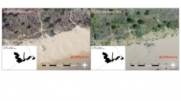
After an initial monitoring carried out to provide objective pre-intervention data, two years later the 2020 monitoring activity allowed the morphological, ecological and dynamic characterisation of the five project areas following the implementation of the requalification interventions. In particular, it was possible to verify the effectiveness of the interventions in reducing the anthropic impact on the habitats, through the detailed mapping of the minor access routes to the beach (paths) and the areas with the highest tourist load.
In order to obtain comparable data, the methodology used for the in itinere monitoring in 2020 was the same as that used in the ex ante phase in 2018.
The monitoring action began with an aerial photogrammetric survey, carried out using a Remotely Piloted Aircraft System, equipped with a compact camera that takes photographs according to a previously planned grid and communicates with the ground station via a radio signal. The flights were carried out at an altitude of 145 metres above the ground. A total of 316.6 hectares were flown over and 3,631 were taken, with an accuracy of the order of centimetres and a frame resolution of 5 cm pixels on the ground.
The GPS survey made it possible to have a number of control points which were used, during data processing, to correct the georeferencing of the three-dimensional model and the photo-plans produced by aerial photogrammetry. As far as the absolute position of each object is concerned, the maximum deviation can be 15 cm, while for the reciprocal distances the accuracy can go up to 5 cm, limited more than anything else by the resolution of the image.
Apart from special cases, such as the presence of water, dense vegetation or very tall trees, the digital model faithfully shows the shape of the bare ground, buildings, tree and shrub tops, shrubs and very dense herbaceous species..
;
From the analysis of the data, path demarcation is confirmed to be a very effective action to limit anthropogenic disturbance. The most evident effects can be seen at the Punta Capalonga site, where the area has been reduced by about 65%. They are reduced to approximately -9% at the Vallevecchia site and completely disappear at the Laguna del Mort site.
Although it is not evident from the data reported, this decreasing trend in the effectiveness of the interventions is at least partly attributable to the different control and monitoring regime of the three areas, which has an inverse trend. The Capalonga site is a relatively small area, facing a campsite, whose managers promptly joined the project and actively collaborated in the monitoring of the area and in the education and communication activities provided by the project. In the other two cases, we are dealing with large stretches of free beach, partially guarded in the case of the Vallevecchia site, and poorly guarded in the case of the Laguna del Mort site, where numerous acts of vandalism to the information panels and walkways and fences positioned by LIFE REDUNE also occurred.